


Google has recently added a couple of features to the already feature-packed Google Maps.
Since Google Maps is one of the most popular navigation apps, it is only right that the company continues to bring better enhancements to the app to make sure that they are not ousted in their place. If Waze, another navigation app owned by Google, boasts of its social features, Google Maps has cool features that will make your travel easier and more convenient.
Time Travel Feature
One of its most recent updates is the time travel feature. It’s not a time travel feature where you can go literally back in time but it does make you feel like you’re traveling several years back. When you search for a specific place, especially major cities, you will have the option of looking at different photos of the area dating seven years back. If you like being nostalgic, you will definitely have fun trying out this new feature.
Bike Routes in Six European Countries
Another recent update from Google Maps is for the people living in six European countries: France, Germany, Ireland, Poland, Liechtenstein, and Luxembourg. Let us correct that; this update is for the people in these countries who love to use bicycles as their form of transportation. Google Maps has added bike directions to these European counties which they can also use with voice turn-by-turn directions. Google Maps also added cycling routes in these six European countries. Tour de France is added as a cycling route and this can be activated from the menu to search for the nearest cycling trails.
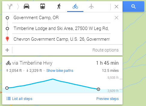
Elevation for Bike Directions
Google Maps has also added elevation to bike routes that you’ve plotted out. Bike direction is activated by typing in an address, picking a route, and selecting the bike option. If before, you can only get a sense of the elevation of an area and the feet of the elevation is not given, now, you will be given the exact number of feet you will climb or decline. A little chart is added below that shows the estimated time of the elevation you’ll be cruising through.
Avoid Steep Hills
If you’re not a fan of steep hills, this new feature will prove to be a big help to you. By knowing how many feet you will have to climb up or down, you can avoid steep hills and just enjoy biking for miles without having to worry about such things. On the other hand, if you live for adventures like this, you can still use this feature to know which side of the hill you’ll be barreling down.
Not Available in Mobile Apps Yet
If the route you’re going to take does not have any elevation, it will be shown as a flat profile. As of the moment, the elevation feature is only available in the desktop version of Google Maps although it will surely roll out in the mobile apps in the future. If you’re planning to ride your bike today, make sure that you map it out on your computer first before setting out.
Related ItemsGoogle Maps